
 Русский
 Тоҷикӣ
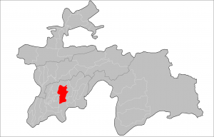
Dangara district – is one of the mountainous regions of the Republic of Tajikistan, with a territory of 2,007 km² formed on July 8, 1932 and is part of the Khatlon region of the Republic of Tajikistan. The population of Dangara in 2015 was 135 thousand people who live on 8 jamoats (large settlements).
The name of the district in the native Tajik language is “Noyiyai Dan’ara”, the administrative center of which is the town of Dangara. The region is famous for the fact that the Tajik Prezident was born and grew up in the area.
Geography of Dangara
Dangara is located 16 kilometers southeast of the capital of Tajikistan, Dushanbe city, the distance from the regional center of Kurgan-Tube is 76 kilometers. The Dangara district is located in the west of the Vakhsh ridge, in the valley of the Vakhsh river. In the north it borders with Nurek, in the east – with Temurmalikskie Vose Districts, in the west – with Javan and Jami, in the south – with Farhoram and Sarband. Height above sea level in the territory of Dangara is from 600 to 1990 meters.
Map of Dangara
Weather in Dangara. The climate of Dangara is dry and warm. In summer, the air temperature is up to +36 and in winter to -15 degrees Celsius. Annual precipitation of 400-500 ml. The territory of Dangara District is a huge forest area. Here grow pistachio trees, dog rose, hawthorn, mulberry, meet wild beasts The region has a huge supply of water and windy energy resources.
The region has a large oil and gas field in the Sargazon village. With the indirect extraction of liquid ore with rare chemical elements, the gas boundary and its volume are being refined. On the territory of the district on the banks of the rivers Vakhsh and Tohir-su there is a large stock of inert building materials: sand and gravel. There is a deposit of onyx marble in the area of Pushing. In the area Pasi-Gatch – limestone construction (calcium I grade).
Economy of Dangara:
The main activity of the population is agriculture, including cotton growing, grain growing, horticulture, viticulture, beekeeping, cultivation of silkworm cocoons. The total area of arable land in Dangara is 28 153 hectares of which irrigated land is 78 65 hectares. 3 003 hectares are used for cotton planting, 36,666 ha for crops, 2,263 ha for gardens, 2,032 ha for vineyards, 656 ha for vegetable crops, and 690 ha for melons. The number of cattle is 43 894 heads, 336 493 (goats and sheep), birds 69 831 heads, horses 5 393 heads.
The region also has industrial enterprises and facilities such as a leather processing plant, engraving, brick, cotton ginning plants, a bakery, a flour mill, a garment factory.
Sangtudinskaya HPP-1 operates in the territory of the district, and Sangtudinskaya HPP-2 is under construction. The district includes 8 rural settlements, 1,038 dehkan farms, 3 collective farms, 2 subsidiary farms. The construction of engineering communications and the infrastructure of the free economic zone of FEZ “Dangara” is underway at the territory of the district. The Dangara FEZ area is unique in that it is located near the Sargazon area, where there are deposits of gas and oil, a huge stock of inert materials. On the border of the FEZ is the railway, in 20 km there is HPP Sangtuda-1 and HPP Sangtuda-2. There is a huge supply of wind and solar energy resources, a cheap productive force. 12 km from the free economic zone is located. Dangara with a large production potential. The Kurgantyube-Kulyab railway passes through the territory of the district.